Day 1 – Mon 10 Aug
- drive Navajo Lake TH [7:00, leave 06:00]
- backpack in [6.2 mi, 3,000′, 4:30]
- camp Navajo Basin [~11,200′]
Day 2 – Tue 11 Aug
- climb Mount Wilson-El Diente: up North Buttress, traverse, down North Slopes
- camp Navajo Basin
Day 3 – Wed 12 Aug
- climb Wilson Peak: West Ridge or Gladstone Peak
- backpack out
- drive to Durango [2:00]
- motel Durango
Day 4 – Thu 13 Aug
- train to Needleton [dep 08:45, arr 11:15]
- hike in [6.6 mi, 3,000′, 4:40]
- camp Chicago Basin [~11,300′]
Day 5 – Fri 14 Aug
- climb Mount Eolus & North Eolus: Northeast Ridge [6.1 mi, 3,600′, 03:30 start, 7:00 est]
- gw exits, rest of group stays
Day 6 – Sat 15 Aug
Sky Stuff:
- Sunrise: 06:25
- Moon: Waning – 58% to 12%
Attendees:
Navajo Basin – Dolores County Sheriff’s Department: 970-677-2257
Chicago Basin – La Plata County Sheriff’s Department: 970-385-2900
Let’s meet at the Coorstek lot in Golden by 04:55 so we can get a 05:00 departure. There’s seven eight of us, so two cars should suffice. Travel time should be 1:20. We’ll park in the lot on the east side of the lake, as the last bit of road to the Mitchell Trailhead is not open.
From what I can glean on conditions, I think there might be a bit of snow. 😃 Seriously, there will undoubtedly be more snow than we’d like, but that’s the theme of the summer. Expect to posthole before we get to the scramble. As I’ve not done this route, we’ll gauge conditions as we go. As it’s a ridge, I hope the snow has cleared. The crux is a notch (down then up-climb) and I’m not sure if the snow will make this worse of better. If worse, be prepared for a turn-around and a breakfast burrito in Boulder.
Once atop Audubon, we’ll assess whether to try the Paiute traverse or descent the East Slopes of Audubon. If Paiute, I expect there’s going to be a few glissading opportunities, so we’ll use those ice axes.
Bring helmets (of course), ice axes, microspikes, clothing to roll around in the snow in, and — I dunno — optional snowshoes?
- early start
- drive to Mitchell Lake TH
- Southeast Ridge to Mount Audubon (class 3)
either
- Traverse to Paiute Peak via Paiute East Ridge (easy class 3)
- Descend via Paiute Southeast Face
- 7 mi RT, 3,300′
or
- Descend via Audubon East Slopes
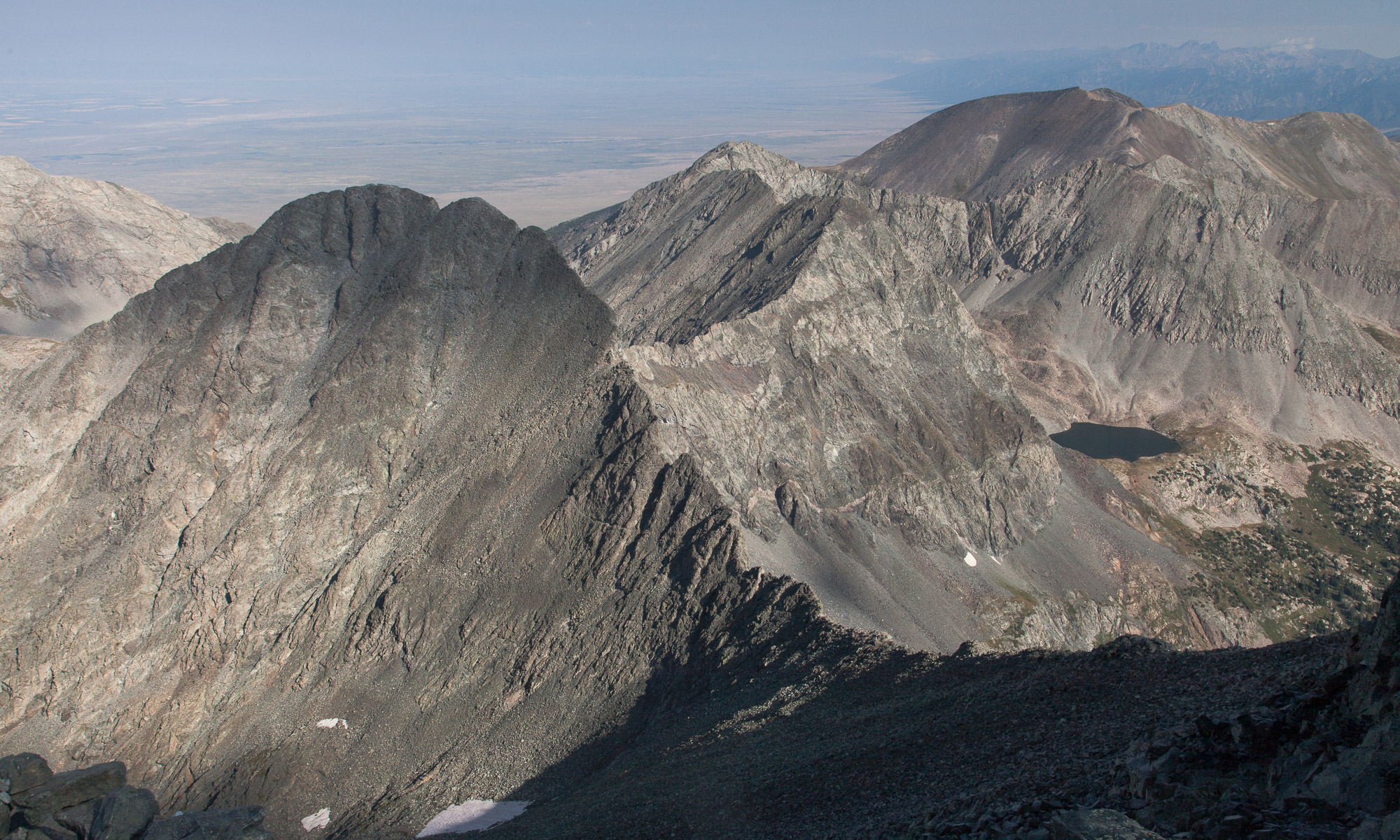
Photo:
Audubon with our ridge is the one in the middle:

Paiute Peak, pointy peaky center right is the SE face of Paiute Peak aka the descent route:

(from Ben, taken on Sat 22 Jun)
Map:
https://caltopo.com/m/71VS
[Route in magenta]

Trip Reports:
Weather Forecast
https://forecast-v3.weather.gov/point/40.0991,-105.6159
Attendees:
- Greg W
- Heather K?
- Cyndi L
- Dave L
- Karin H
- Ben B
- Jan B
- Ken Y
Day 1 – Thursday 29 Aug
- drive [3:30]
- 4WD South Colony Lakes TH [3 mi]
- hike in [4.4 mi, 1,710′]
- camp Lower Colony Lake [11,660′]
Day 2 – Friday 30 Aug
- climb Crestone Needle via South Face [2.6mi RT, 2,537′]
- hike out [4.4 mi, -1,710′ (-4,247′ total)]
- 4WD out
- drive to Lily Lake TH
- camp near Lily Lake TH
Day 3 – Saturday 31 Aug
- climb Mount Lindsey via Northwest Ridge, [8.6 mi RT, 3,492′]
- drive back [4:00]
Condition Reports:
Sky Stuff:
- Sunrise: 06:30
- Moon: New – 0.6%
Maps:
Crestone Needle – Cal Topo Map

Mount Lindsey – Cal Topo Map

Attendees:
- Greg W
- Heather K
- Georgia C
Dates not final
The 4WD road from Crystal to Lead King Basin is not recommended when wet, so this itinerary reflects both dry and wet conditions.
Day 1 – Thu TBD
- drive Crystal [4:00]
- if dry
- 4WD to Lead King Basin
- backpack from Lead King Basin TH to Geneva Lake [1.75 mi, 1,400′]
- camp Geneva Lake [11,000′, campsite #2]
- if wet
- backpack from Crystal pull-out to Geneva Lake [3.5 mi, 2,200′]
- camp Geneva Lake [11,000′, campsite #2]
Day 2 – Fri TBD
- climb Snowmass: up South Ridge, down West Slopes [4.8 mi RT, 3,300′]
- if dry
- backpack out
- 4WD & drive back
- if wet
- camp Geneva Lake [11,000′, campsite #2]
Day 3 – Sat TBD
- climb more mountains
- backpack out, 4WD & drive back
Trip Reports
Map
Snowmass Map
Attendees:
Gunnison County Sheriff’s Department: 970-641-1113